

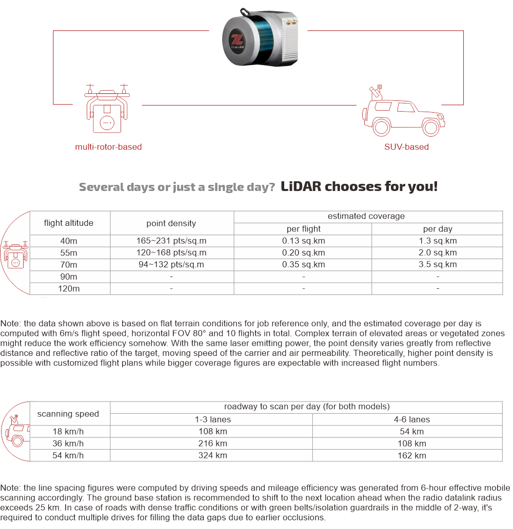
LiDAR SZT-V100
- Absolute accuracy down to 10 cm
- ● Extremely lightweight, less than 1.5 kg
- ● An economical LiDAR solution
- ● Multi-platform (UAV/SUV) applications
Additional information
| Weight | 1.5 kg |
|---|---|
| Dimensions | 116.5 × 112 × 123 mm |
Specification
| LiDAR System | Laser Channels | 16 channels |
| Laser Range | max. 100 m | |
| Field of View | +15.0° to -15.0° (30°) (Vertical); 360° (Horizontal) | |
| Angular Resolution | 2.0° (Vertical); 0.1° to 0.4° (Horizontal/Azimuth) | |
| Max. Means Rate | Single Return Mode: ~300,000 points per second Dual Return Mode: ~600,000 points per second | |
| Accuracy | Relative Accuracy: 5 cm; Absolute Accuracy: 10 cm | |
| Camera Effective Pixels | 24.3 MP, RGB | |
| Recommended scanning height AGL | 10-80 m | |
| Net Weight | 1.5 kg (w/o camera) | |
| Dimensions | 116.5 x 112 x 123 mm | |
| Input Voltage | 11-18 V DC | |
| Power Consumption | 20 W | |
| Data Storage | 256 GB SSD | |
| Part I: Laser Scanner | Type | Velodyne VLP-16 |
| Wavelength | 903 nm | |
| Eye Safety Class | — | |
| Laser Product Classification | Class 1 Eye-safe-per IEC 60825-1:2007 & 2014 | |
| Laser Pulse Repetition Rate | — | |
| Range Accuracy | up to ±3 cm (typical) | |
| Accuracy/ Precision | — | |
| Rotation Rate | 5 Hz ~ 20 Hz | |
| Scan Speed | — | |
| Multi-echo effect | 2 echo returns | |
| Data Storage | — | |
| Environment Protection | IP67 | |
| Temperature | operating: -10℃~60℃; storage: -40℃~80℃ | |
| Part II: POS System | Type | Inertial Labs INS-D-OEM |
| Gyroscopes Bias in-run Stability | 1 deg/hr (RMS, Allan Variance) | |
| Gyroscopes Measurement Range | ±450 deg/sec | |
| Accelerometers Measurement Range | ±8 g | |
| Post Processing Roll/Pitch Accuracy | 0.006 deg RMS | |
| Post Processing Heading Accuracy | 0.03 deg RMS | |
| Post Processing Position H/V Accuracy | 0.005/0.01 meters, RMS | |
| Post Processing Velocity H/V Accuracy | 0.02/0.01 meters/sec, RMS | |
| Data Sampling Rate | IMU: 200 Hz, GNSS positions: 5 Hz | |
| Internal Memory | — |
Note: all information above is subject to change without any prior notice.
Brochures Download
Application
You must be logged in to post a review.
Related products


Explore our full range of professional geomatics equipment designed to meet the demands of modern fieldwork across a wide variety of industries. From high-precision GNSS systems and total stations to rugged data collectors, UAV and drone solutions, and advanced LiDAR technology, every product we offer is carefully selected for performance, durability, and ease of use in real-world conditions.
Whether you are conducting land surveying, construction layout, mapping, or managing complex geospatial data, Geomatics Gear provides reliable tools that help you maintain accuracy and efficiency on every project. Our solutions are built to perform in challenging environments, ensuring consistent results when it matters most.
In addition to top-tier equipment, our team offers knowledgeable support to help you choose the right tools for your workflow. With Geomatics Gear, you gain access to trusted technology and expertise that keeps your projects moving forward with confidence.
Reviews
There are no reviews yet.