South New S86
$6,510
- CAD: $8,997.73
- Adhering to the excellent quality and creating the high-end brand, the new S86 leads the new standard of the RTK measurement with multiple constellations and multibands receiving technology. Fusing strong practicability of the high precision integration, brings unparalleled efficiency measurement experience for the user.
Features


Additional information
| Weight | N/A |
|---|---|
| Dimensions | N/A |
| Model S86 | S86BG, Base Receiver, BD970 220 channels, colorful LED reading, built-in batteries,4G, UHF module 410-430/430-450/450-470MHz, S86RG,Rover Receiver, BD970, 220 channels,colorful LED reading, built-in batteries,4G,UHF module 410-430/430-450/450-470MHz |
Specification
| GNSS performance | Channels | 220 |
| GPS | L1C/A, L2C, L2E, L5 | |
| GLONASS | L1 C/A, L1 P, L2 C/A (GLONASS M Only), L2 P | |
| BDS | B1, B2 | |
| GALILEO | E1 BOC, E5A, E5B, E5AltBOC | |
| SBAS | L1C/A, L5 (Just for the satellites supporting L5) QZSS, WAAS, MSAS, EGNOS, GAGAN |
|
| L-Band | — | |
| Positioning output rate | 1Hz~50Hz | |
| Initialization time | <10s | |
| Initialization reliability | >99.99% | |
| Positioning precision | Static surveying | Horizontal: 2.5mm+0.5ppm; Vertical: 5mm+0.5ppm |
| Code differential positioning | Horizontal:0.25m+1ppm; Vertical:0.50m+1ppm | |
| Real-time kinematic surveying | Horizontal: 8mm+1ppm; Vertical: 15mm+1ppm | |
| RTX | — | |
| SBAS positioning | Typically<5m 3DRMS | |
| xFill | ||
| IMU tilt compensation | ||
| Single positioning | — | |
| User interaction | Operaing system | Linux |
| Buttons | 4-button operation | |
| LCD | 1.54 inch HD OLED screen with resolution 128 x 64 | |
| Indicators | 4 indicators, indicates mode settings and status | |
| Web UI | Allows to control and monitor the receiver in webserver through WIFI or USB, freely to configure receiver | |
| Voice guide | Support multiple languages, Chinese/English/Korean/Spanish/Portuguese/Russian/Turkish supported | |
| Secondary development | The OpenSIC observation data format and interative interface support secondary development | |
| Data cloud service | — | |
| Hardware performance | Dimension | 165mm(L) × 168mm(w) × 122mm(H) |
| Weight | 1.85kg (battery included) | |
| Material | — | |
| Operating temperature | -45°C ~ +60°C | |
| Storag temperature | -55°C ~ +85°C | |
| Humidity | 100% Non-condensing | |
| Waterproof/Dustproof | IP67 standard, protected from long time immersion to depth of 1m, and fully protected against blowing dust | |
| Shock and vibration | Withstand 3 meters pole drop onto the cement ground naturally | |
| Power Supply | 9-25V DC, overvoltage protection | |
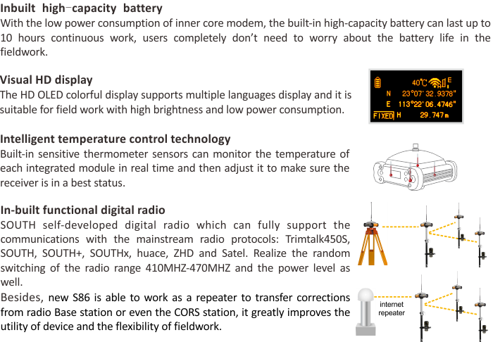
| Battery | 7.4V, 6800mAh internal Li-ion battery, rechargable | |
| Battery solution | — | |
| Battery life | 16h (static mode); 10h (internal UHF base mode); 12h (rover mode) | |
| Communications | I/O port | 5-PIN LEMO external power port+Rs232; 7-PIN LEMO+external USB(OTG+Web accessing; 1 UHF/GPRS antenna interface; SIM card slot |
| Wireless modem | Integrated internal radio receiver and transmitter, 1W/2W/3W optional; UHF repeater function | |
| Frequency Range | 410-470MHz | |
| Communication Protocol | TrimTalk, SOUTH, SOUTH+, SOUTHx, huace, ZHD, Satel | |
| Cellular Mobile Network | TDD-LTE/FDD-LTE 4G network modem | |
| Double Module Bluetooth | Bluetooth V2.1/ Bluetooth V4.0, support EDR | |
| NFC Communication | — | |
| External Devices | Optional external GPRS/EDGE dual-mode communication module, switchable; allow to connect external WLAN card | |
| WIFI | Standard | 802.11 b/g standard |
| WIFI Hotspot | The WIFI hotspot allows any mobile terminal to connect and access to the internal webserver for the control and moditor receiver | |
| WIFI data link | To work as the datalink that receiver is able to broadcast and receive differential data via WIFI | |
| Data storage/ Transmission | Data Storage | 8GB SSD internal storage, supports external USB storage and automatical cycle storage, changeable record interval, up to 50Hz raw data collection |
| Data Transmission | USB data transmission, supporting FTP/HTTP data download | |
| Data Format | Static data format: STH, Rinex2.x and Rinex3.x etc Differential data format: CMR+, CMRx, RTCM 2.1, RTCM 2.3, RTCM 3.0, RTCM 3.1, RTCM 3.2 GPS output data format: NMEA 0183, PJK plane coordinates, binary code, Trimble GSOF Network model support: VRS, FKP, MAC, supporting NTRIP protocol |
|
| Inertial sensing system | Tilt survey | Optional, built-in tilt compensator, correcting coordinates automatically according to the tilt direction and angle of the centering rod |
| Electronic bubble | Optional, controller software display electronic bubble, checking leveling status of the centering rod real time | |
| Thermometer | Optional, built-in thermometer sensors, adopting intelligent temperature control tech nology, monitoring and adjusting the receiver temperature in real time |
Note: all information above is subject to change without any prior notice.
Brochure Download
You must be logged in to post a review.


Reviews
There are no reviews yet.